Posts

Showing posts from May, 2022

2022-5-20, Bushy Hill Nature Preserve, Essex, CT

Image
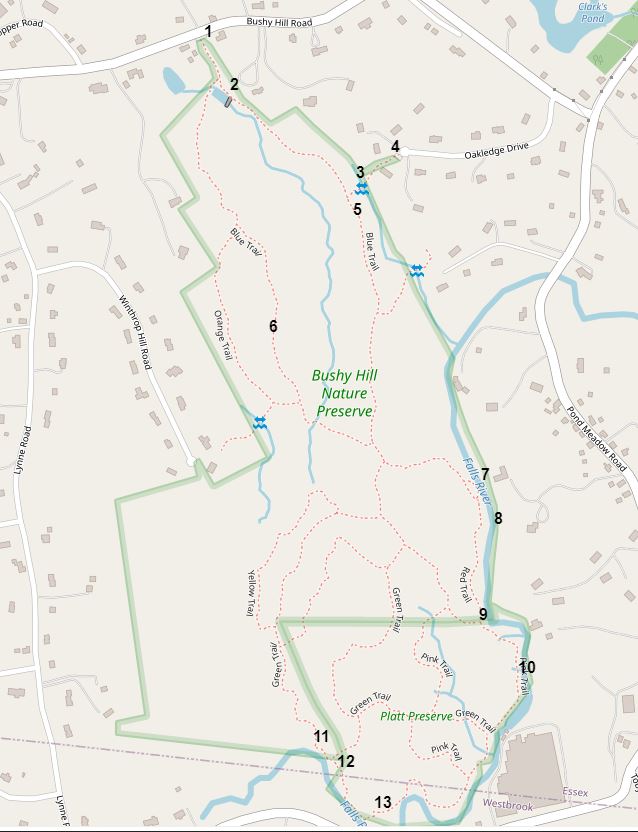
 On 2022-5-20, I visited Bushy Hill Nature Preserve in Essex, CT, and the adjoining Platt Preserve, which is in both Essex and Westbrook. I made an interactive map with location numbers.  Here's a link to the interactive map:  https://arcg.is/feW48 Here's a static screenshot of the interactive map. 1.  A map kiosk near a small parking area that could hold maybe four cars. 6.  I think the rough section on the bark of this American Beech was the result of a disease.  The tree was dead. 11.  Falls River. 12.  Rocks. 13.  Old Mountain Laurel. 10.  Falls River. 9.   Above Falls River. 8.  Rocks on the far side of Falls River. 7.  More rocks on the far side of Falls River. 5.  A large White Oak. 3.  The map kiosk at the Bushy Hill Road parking area had this message: "Additional parking and entrance can be found at the end of Oakledge Drive.  Parking area marked in front of 25 Oakledge Drive and trail is marked."  There were markers showing where the trail was, but the trail

2022-5-10, Goodbody Preserve, Sharon, CT

Image
 On 2022-5-10, I visited Goodbody Preserve in Sharon, CT.  Goodbody Preserve is a Sharon Land Trust Property,  https://sharonlandtrust.org/  . I made an interactive map of the preserve with location numbers.  Here's a link to the interactive map:  https://arcg.is/CPzfS0  . Here's a static screenshot of the interactive map. 1.  There was a grass parking area that could hold, perhaps, ten cars.  There was a "Sharon Land Trust Nature Trail" sign visible from the road if you were going northerly. 2.  I tried to identify this flowering shrub.  With iNaturalist.org, I came up with the identification of Jetbead, Rhodotypos scandens.  I read on Wikipedia that Jetbead is native to China, Korea, and maybe Japan. 2.  Note the opposite leaves. 2.  And opposite branches. 3.  I tried to identify this flower, also with iNaturalist.org.  The best I could do was American Groundsels and Ragworts, Genus Packera. 3.  The leaves near ground level.  Apparently the plant has leaves of diffe

2022-5-11, Metacomet Trail, Berlin, CT

Image
 On 2022-5-11, I hiked a section of the Metacomet Trail (blue blazes), and the Metacomet Loop Trail (blue-red blazes), in Berlin, CT. This map shows where I recorded GPS Waypoints.  I recorded a Waypoint each time I took a picture. Here's a link that will take you to the interactive version of the map:  https://arcg.is/1e1fD1 001.  Why is a left turn indicated here?  A very nice map that the Town of Berlin must have had made. 002.  Two blow-downs on the blue-red trail. 003.  Painted-over blazes on what I think used to be a short blue-white trail. 004.  A nice angle-iron bridge on the blue-red trail. 005.  A low blow-down on the blue-red trail. 006.  The blue-red trail meets the blue trail. 007.  A ford on the blue trail.  Not a problem on 2022-5-11. 008.  This spot has gotten overgrown in the past.  Not a problem as of 2022-5-11.   Small poison ivy plants were visible. 009.  A low blow-down. 010.  Two blow-downs. 011.  A blow-down. 012.  A hanging blow-down. 013.  At first I though