Posts

Showing posts from November, 2020

2020-11-25, Reservoir Cellar Hole Discovery, West Hartford, CT

Image
 On 2020-11-25, I discovered a cellar hole in West Hartford on Metropolitan District Commission land. Do you see the depression in the center of the picture?  I think it is what's left of a cellar hole, built maybe in the early 19th century.  Location on www.openstreetmap.org:  https://www.openstreetmap.org/way/877690233  . Here I am standing in the cellar hole. I found the cellar hole by using LIDAR imagery available from UConn.  The image below is a screenshot from an interactive ArcGIS map I made.  A is a still-in-use trail.  B is an old thoroughfare mostly visible only on LIDAR.  C is the cellar hole.  D is a faint thoroughfare to the cellar hole visible only on LIDAR.  On my interactive map, you can turn on and off various layers including LIDAR, photographic aerial imagery, my GPS track and Waypoints.  Here's a link to my interactive map:  http://arcg.is/54KCu0  . David Reik

2020-11-12, Dismal Brook Wildlife Preserve, Granby, CT

Image
On 2020-11-12, I visited a new Granby Land Trust preserve, Dismal Brook Wildlife Preserve in Granby, CT.  I made an interactive map with location numbers that I will refer to below.  Here is a link to the interactive map:  http://arcg.is/1PyTGa  . Here is a static screenshot of the interactive map. 1.  Where I parked in a large, gravel parking lot. 2.  The view from one of two wildlife viewing platforms. 3.  Note that this new bridge is curved. 4.  The Day family farmed the land that is now the preserve for centuries.  Here, there is a cemetery where five people were buried from 1795 to 1850.  On my computer, I can right-click on any of the images in this blog and open the image in another tab to see more detail.  You can get more information about the cemetery at  https://granbylandtrust.org/glt/wp-content/uploads/2020/11/Day-Cemetery-May-2008-SBHS-Report.pdf  . 4.  Who was the artist who produced this image? 4....

2020-11-16, Trolley and Railroad Routes, Cheshire and Prospect, CT

Image
 On 2020-11-16, I visited an abandoned trolley route, and also an abandoned railroad route, on the border between Cheshire and Prospect.  Here's a link to an interactive map I made on which I put location numbers that I will refer to below.  http://arcg.is/a81bH  .  Below is a static screenshot of the interactive map. 1.  Where I parked in the main Mixville Park parking lot in Cheshire, CT. 2.  I walked from the parking lot to the top of a sledding slope. 3.  I walked along a path on the old trolley route to Notch Road where there was still a bridge over Notch Road that used to take the trollies over Notch Road.  On www.OpenStreetMap.org, there is a route visible on some platforms that is named, "Waterbury-Cheshire Trolley Line." 3.  About 100 feet north of Notch Road, the trolley route crosses Mountain Brook. 3.  Mountain Brook. 3.  David Reik with Mountain Brook. 4.  A cut through the rock on the trolley path. 5.  T...

2020-11-14, Quinnipiac Trail, Prospect, CT

Image
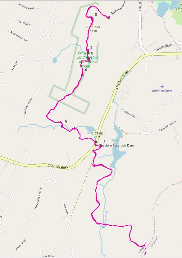
 On 2020-11-14, Bill Shortell and I hiked the new northern-most three miles of the Quinnipiac Trail mostly in Prospect, CT.  Here's a link to an interactive map I made with location numbers that show where the pictures below were taken, as recorded by our iPhones.   http://arcg.is/00491G0  .  Below is a static screenshot of the interactive map. 1.  This was posted near where we parked in the turnaround at the end of Boardman Drive in Prospect.  This map only shows the Prospect Land Trust trails in Kathan Woods, the preserve that the Quinnipiac Trail now ends in, as you hike northerly ---- the new Quinnipiac Trail route is not shown. 2.  Bill Shortell wandering around in what looked like a center-chimney cellar hole. 3.  We saw lots of steel (or are they iron?) culverts on South Central Connecticut Regional Water Authority land. 4.  A cell tower. 5.  More steel culverts. 6.  Bill thought this looked like bottles left for th...

2020-11-11, Two Blowdowns on CFPA Trails, Heublein Tower Area

Image
 On 2020-11-11, I cut several blowdowns in the Heublein Tower area.  Two of the blowdowns I cut were on Connecticut Forest and Park Association Trails, the Metacomet Trail for the first blowdown, and the Blue-Red Heublein Bypass Trail for the second blowdown.  I cut several other blowdowns on unblazed trails. CFPA Blowdown 1.  This was a fallen hemlock tree.  I used my new dry-wood blade in my Bahco 36-inch bow saw.  Note the pileated woodpecker holes. I only made one cut.  The trail is still partially blocked. How old was this tree? The white marker shows the location of the blowdown, as recorded by Judith's iPhone 5s. CFPA Blowdown 2.  While walking southerly to a blowdown I wanted to cut on an unblazed trail that runs along the fence between MDC and private property, I came to this blowdown on the Blue-Red Heublein Bypass Trail.  It was a white ash. I made two cuts.  For the first cut, I needed to use both by Bahco bow saw and the pru...