2022-4-6, R.H. Collins Preserve, Portland, CT
On 2022-4-6, I visited the R.H. Collins Preserve in Portland, CT. The preserve is owned and maintained by Middlesex Land Trust, https://middlesexlandtrust.org/preserves-maps/ .
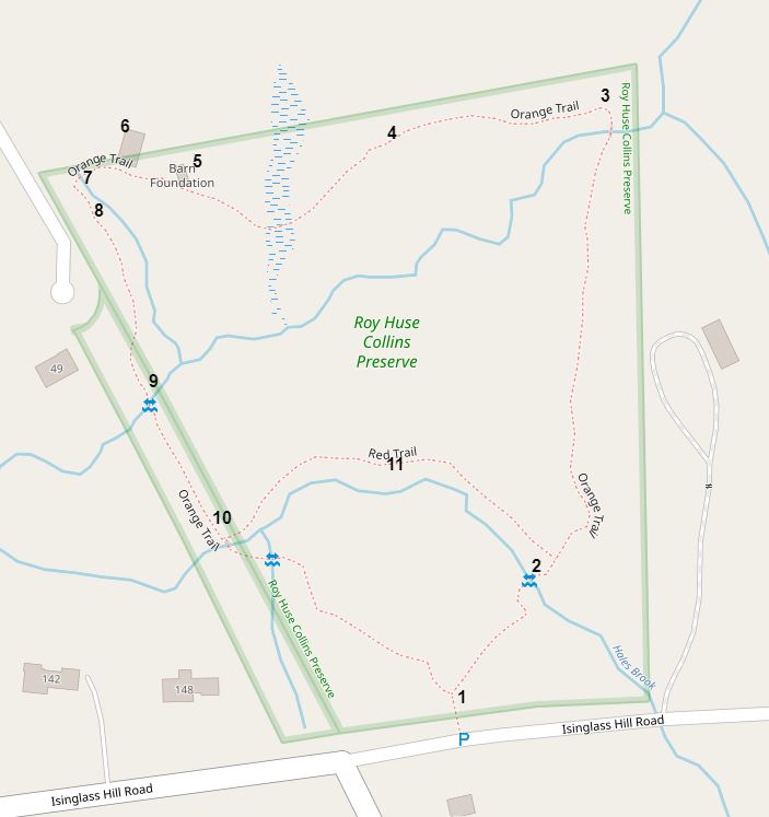
I made an interactive map of the preserve. Here's a link to the interactive map: https://arcg.is/1rD9yj0 . I put in location numbers on the interactive map. Here's a static screenshot of the interactive map.
1. I parked on Isinglass Hill Road in Portland, CT, near the intersection with Thompson Hill Road.
1. A nice map kiosk.
2. The Orange Trail crosses Hales Brook here on rocks.
2. The crossing from the other side.
6. This looks like it was the support for a center chimney in what the Middlesex Land Trust map labels the "Hale Homestead Foundation." Was this Hale family related to State Hero Nathan Hale?
8. The Orange Trail goes around the roots of a fallen tree here. There are stepping stones through the water.
9. The Orange Trail crosses a tributary to Hales Brook using large, flat rocks.
9. The other side of the crossing on flat rocks.
10. A stone bridge over Hales Brook.
11. A view from near the Red Trail. Is this an old dam, or just a stone wall that crosses Hales Brook?
3. A wooden bridge with an anti-slip wire mesh covering.
3. Another view of the bridge. There is some sort of man-made material supporting one end of the bridge.
4. Evidence of recent blow-down cutting.
5. I thought this was a barn foundation.
7. A stone bridge over a small stream.
David Reik


Comments
Post a Comment