Posts

Showing posts from April, 2022

2022-4-6, Upper Pine Brook Preserve, East Hampton, CT

Image
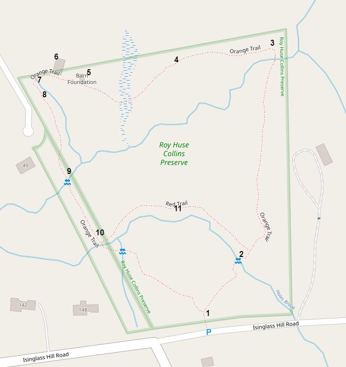
 On 2022-4-6, I visited Upper Pine Brook Preserve, in East Hampton, CT.  The preserve is owned and maintained by the Middlesex Land Trust,  https://middlesexlandtrust.org/ I made an interactive map of the preserve with location numbers.  Here's a link to the interactive map:  https://arcg.is/vyOrS  .  Here's a static screenshot of the interactive map. 1.  I parked on the grassy shoulder of Chestnut Hill Road. 1.  A Middlesex Land Trust map kiosk. 2.  The trail was well-blazed, but hadn't been recently cleared when I visited. 3.  Another one of the many blow-downs on the orange-blazed trail.  There were many other blow-downs, but the abundant, clear blazes made following the trail not too difficult. 4.  A view of the stream that the orange-blazed trail travels along.  The stream flows into Pine Brook.  Maybe this stream is called Upper Pine Brook. 5.  Why was this tall stone wall built along the stream? 5.  Green False Hellebore, Veratrum viride, growing on the side of the b

2022-4-6, Pine Brook Falls, East Hampton, CT

Image
 On 2022-4-6, I visited Pine Brook Falls Preserve, a part of the Silvio O. Conte National Fish and Wildlife Refuge. I made an interactive map of the preserve with location numbers.  Here's a link to the interactive map:  https://arcg.is/1PeHTT0  . 2.  There are many of these boundary signs. 5.  Pine Brook Falls appears to be a natural falls intermixed with stone construction that I think was made around 1840 for a mill operation.  I think this picture shows the ruins of a millrace that brought water from the dam to a mill wheel. 5.  Pine Brook Falls from above. 5.  Pine Brook Falls from above. 5.  I saw something move on the side of the falls.  A furry object  appeared to convulse.  This is as close as I got.  I decided it was a distressed coyote, or maybe just a sleeping coyote.  Now, with input from Facebook Friends, I think it was a beaver. 5. An extreme cropping of the photo you see above.  Note the flat, hairless tail. 5.  Pine Brook Falls from below. 5.  Pine Brook Falls from

2022-4-6, R.H. Collins Preserve, Portland, CT

Image
 On 2022-4-6, I visited the R.H. Collins Preserve in Portland, CT.  The preserve is owned and maintained by Middlesex Land Trust,  https://middlesexlandtrust.org/preserves-maps/  . I made an interactive map of the preserve.  Here's a link to the interactive map:  https://arcg.is/1rD9yj0  .  I put in location numbers on the interactive map.  Here's a static screenshot of the interactive map. 1.  I parked on Isinglass Hill Road in Portland, CT, near the intersection with Thompson Hill Road. 1. A nice map kiosk. 2.  The Orange Trail crosses Hales Brook here on rocks. 2.  The crossing from the other side. 6.  This looks like it was the support for a center chimney in what the Middlesex Land Trust map labels the "Hale Homestead Foundation."  Was this Hale family related to State Hero Nathan Hale? 8.  The Orange Trail goes around the roots of a fallen tree here.  There are stepping stones through the water. 9.  The Orange Trail crosses a tributary to Hales Brook using large