Posts

Showing posts from September, 2021

2021-9-21, Ketchin Quarry, Simsbury, CT

Image
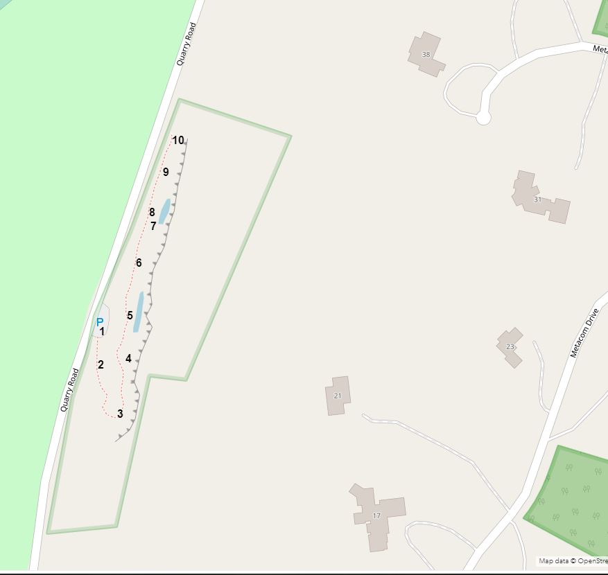
On 2021-9-21, I visited the Ketchin Quarry preserve, a Simsbury Land Conservation Trust property.  I made an interactive map with approximate location numbers.   Here's a link to the interactive map:  https://arcg.is/1a9uOP  .  Below is a static screenshot of the interactive map. 1.  2. 3.  A rock (about one foot long) lying on the quarry path. 4. 4. 4.  I found this shell on a ledge next to where I was standing in the picture. 4.  The underside of the shell.  Those latitude and longitude numbers equate to 41.895417, -72.775 in decimal degrees, a point 178 feet north of where I found the shell. 4.  A close-up of the rock near where I was standing.  Note the thin, flaky layers.  Do other kinds of brownstone have these flaky layers? 5. 5. 6. 7. 8. 9.  Here you can see one of several stagnant pools of water between the base of the quarry cliffs and the path.  The pools may be the source of the abundant mosquitoes in the area. 10. David Reik 

2021-9-9, Barnes Nature Center Connector, Bristol, Burlington, CT

Image
 On 2021-9-9, I walked a section of the Connecticut Forest and Park Association Barnes Nature Center Connector, blazed with blue blazes with black dots.  Here's a screenshot from the CFPA online map overlaid with my GPS track (no antenna) shown in pink. Here's a screenshot of an ArcGIS map showing the GPS Waypoints that I recorded. Here's a link to the interactive map:  https://arcg.is/1LPySP  . Barnes Nature Center Parking Lot.  The kiosk says that Barnes Nature Center intends to transform most of their existing trails into "a mile-long nature trail" that "will be accessible to people using wheelchairs, strollers, walkers, and other mobility devices."  The route they show involves a lot of altitude change.   001.  A blow-down. 002. Another blow-down. 003.  Another blow-down.  I was cutting what I could with my loppers. 004.  A section of the trail that runs by a fence that gets overgrown.  There was a lot of poison ivy in the vegetation shown. 005.  Pin

2021-9-3, Lantern Hill, North Stonington, CT

Image
 On 2021-9-2 and 2021-9-3, I visited the Lantern Hill area in North Stonington, CT.  I made an interactive map with location numbers that I will refer to.  Here's a link to the interactive map:  https://arcg.is/1yO44y0  .  Here is a static screenshot of the interactive map. 1.  Where I parked, in a pull-off on Wintechog Hill Road.  Perhaps ten cars could fit in the pull-off.  In the pre-COVID days, I hear it was possible for people hiking the Lantern Hill trails to park in the Two Trees Inn parking lot.   2.  I followed the blue-blazed Narragansett Trail to the top of Lantern Hill.  There are different viewpoints near the top of Lantern Hill.  From 2, you could see northwesterly, towards the Foxwoods buildings. 2.  You could also see westerly, towards Lantern Hill Pond. 3.  Another view of Lantern Hill Pond, from an unblazed trail. 3.  A view to the south, towards Long Island Sound. 4.  There was lots of white rock like this in the area.  "Milky quartz" I believe is what